Sunday, March 31, 2013

Day 11, March 30, 2013 : Around the Brock Pit and in Tottenham Forest

Today we decided not to spent a lot of time for driving and walk the part of Oak Ridges Moraine Trail (ORT) near our Wolfe Rd North of our house.
Brock Pit is at the center of our loop and is full of water now
 We began at the intersection of Mount Wolfe Rd and Caledon Trailway, went South on Mount Wolfe Rd and turned East on the ORT near the Church opposite to Hunsden Sideroad. It was very picturesque path along the Brock Pit which was on the left.
Adopt the ORT (note the white mark on the right tree)

On the ORT

On the ORT

Brock Pit which everybody around is protested against.

After about 1.5 km we reached hwy 9, crossed it and followed North through the Tottenham Forest (officially it's Simcoe County Forest). We like this forest and walked there a few times in summer and fall 2012.
Tottenham Forest

Our way back was South along the Tottenham Rd and West on hwy 9 till the bridge over the railway. Here we adopt Caledon railtrail and came to the car.
I like it in B&W.

Mount Wolfe Rd, ours is silver Corolla.

As you can see from the RunKeeper report it was short but very interesting route for this day,
Only 424 calories burnt :(

Sunday, March 24, 2013

Day 10, March 23, 2013 : Forks of the Credit

Today we returned to "close" a gap on our route and visited The Forks of the Credit Provincial Park. We used to be in this Park many years ago - in 2002 may be and it was a summer time. To really "close the gap" we parked our car at the intersection of McLaren Rd and Forks of Credit Rd. - see Day 7 (3 km point on the map).

After 1-1.5 km North on the McLaren Rd we turned West on narrow dead-end Puckering Lane at the end of which is there access to the Bruce Trale Loop. The trail went along the steep slop of the large and deep ravine. Because snow was compacted on the trail by hikers it still was preserved on the trail and melted away on the slop itself (see picture)

 We didn't follow the whole loop and turned East (sharp 90 degree turn on the map) to the parking lot near the Forks of Credit Rd. Here I took a picture of Irina and the Map of the Park.

Some more pictures from the Park.

Cattle Lake is under ice now.

Contrary to many previous days it was blue sky and white clouds today

We finished our route going South on the McLaren Rd back to our car.

As always final report from RunKeeper.

На обратном пути специально для Ольги, которой понравился вот этот снимок из дня 6-го,

День 6-ой - 23 февраля 2013 г.

мы специально остановились в том же месте и сняли ту же усадьбу уже при солнце и синем небе. Почему-то все равно первый "пасмурный" снимок кажется интереснее.

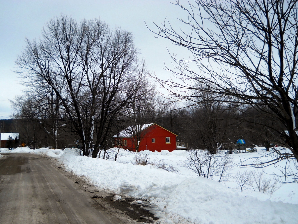
День 10-й, 23 марта 2013 г - ровно через месяц.


Monday, March 18, 2013

Day 9, March 17, 2013 : Terra Cotta, ON

On Saturday it  was like snowstorm and on Sunday was a sunshine though little bit windy. We still tried to chose the route along the roads to avoid a deep snow in the bushes. We drove again the same way on the Old Baseline Rd and first of all visited Inglewood again, because I'd like to take a picture from the same spot I did with our friends almost 4 years ago. Let's compare:

  
In 2009 it was a small Art Gallery there. There is some kind of yoga classes here now.
From Inglewood we drove again on Old Baseline , then turned South on Mississauga Rd and West on King St and came to Terra Cotta. There was a parking spot for the Bruce Trail hikers on Tenth Line West of Terra Cotta. This was where our route began.

Our car on the parking spot, Tenth Line. 

We walked clockwise on the main roads untill 7th km. Then it was "real" Bruce Trail made in snow by previous hikers. The 7th km point is also the beginning of Caledon Railway Trail which goes NNE from here (see map at the kiosk on picture below)

Just a beginning of the route and road went up.

I like the house.

Here we turned to the South On Winston Churchill Blvd which marks a boundary between Caledon and Halton Hills.

Winston Churchill Blvd perspective.

Vanya shows the starting point of the Caledon Railway Trail on the map. And we just are there.

As ususal - report from RunKeeper.

And also as usual picture of both of us taken by Vanya.

Sunday, March 10, 2013

Day 8, March 10, 2013 : Creditview Rd + Boston MIlls Rd + Rockside Rd + Old Baseline Rd Loop

This time Ivan accompanied us as he did on the Day 3. We drove on the Old Church Rd to Caledon East, turned South on Airport Rd and then West on the Old Baseline Rd - the same way as previous Day 7. From the Old Baseline Rd we turned right on McLaughlin Rd to look at the little town Inglewood. We were surprised to discover that many years ago we already visited this town with our friends. We even recognized a small house where the Art Gallery was. We didn't stay at the town and returned to Old Baseline Rd. In a few kilometers at the intersection with Creditview Rd we left our car and walked South on Creditview Rd.


Our car at the intersection of Old Baseline Rd (goes from right to left) and Creditview Rd
After about 1 km we turned right (to the West) on Boston Mills Rd following Bruce Trail signs. There on the left (south) side of the road we noticed a big house where a lot of cars came in. "Spirit Tree" - it was written at the entrance. It's smell like fresh prepared meal. We decided to look at and I stopped my RunKeeper for a while.
Spirit Tree tavern, store, bakery 
We liked the store and friendly personnel. We even bought a bottle of ginger syrup from local farm. Then I turned my RunKeeper on again and we went on Westward on Boston Mills Rd. Unfortunately soon after crossing Mississauga Rd Boston Mills ended and we forced to go through the forest as Bruce Trail did. Happily somebody already walked here and there was a path into snow. Snow was very soft and melted on the sun - it was near +10 C and we began to undress.
It's really beginning of spring.

Snow is melting under the sun.

Ivan took a picture of us.

Report from RunKeeper - you know even calories burnt.

Twice a secure property


Saturday, March 2, 2013

Day 7, March 02, 2013 : Forks of the Credit Rd + McLaren Rd

There is still a lot of snow and we only can walk along the roads. Even some roads are closed for the winter season. So we forced to skip some portions of the trail (will to go in spring) and to drive more to find appropriate routs. Today we stopped at the closed part of The Grange Side Rd (see pic) and then drove to


the intersection of Mississauga Rd and Forks of the Credit Rd. Our starting point was near the bridge when Dominion Rd went North from Fork of the Credit Rd.


This time RunKeeper report was divided into two portions. First one from the red tag to the green one was 3.65 km and second one from green tag to the end of red line and back to the red tag was 4.64 km. The km marks on the map corresponds to the second part.
Some more pictures from our route are below.

Credit River. View East (downstream) from the bridge at the Dominion Rd


 Before turn back we met a guy with a full dozen of dogs Biggles and Bassets in various proportions.

Sunday, February 24, 2013

Day 6, Feb 23, 2013: Along Escarpment Sideroad to the West

This time I was checking new "toy". I installed the RunKeeper software on my HTC Android smartphone and allowed this program to track our walk. Everything was working well, though to hear info every 5 min seemed little annoying.  But at the end of the walk we received the full report on our activity including even the amount of calories burnt. Below is a map as it was done by RunKeeper in my phone. (My negative experience with some features of the RunKeeper - see below).


Because we walked there and back (as a Hobbit) the kilometers seems not to be in order. We went from the top to the bottom of the map initially beginning from the place, where we finished in previous Day 5.
The weather was not so foggy and it didn't snow but there were low grey clouds all over the sky. Some typical pictures are below.

The Tunnel under hwy 10 (Hurontario Rd). You can see this place on the map where the route made a loop at the intersection with hwy 10.


More about RunKeeper. To use the program I registered at their site and was informed that I can share my activities with my friends. They suggested me to put their emails into form and they will be invited. I did this for my wife and a few close friends and was surprised because what they really received was invitation (in imperative mode I'd say) to FULLY REGISTER on the site as if become the full members, though they definitely were not - they only were invited by me to look at MY activities. Without this forced registration they cannot see not only my activity but even the invitation text I sent them. I immediately sent my friends a letters of my apology and withdrew my invitations. Now I'm not sure how many of RunKeeper 500,000 members they mentioned proudly on they site are such "dead souls". Unfortunately it seems becomes a usual practice nowadays.